 FRONTIER
НаукаScience · 2026-10-19 · весь выпускfull edition
NASA опубликовало осенний снимок Бещад: лес и горные луга меняют цвет по-разномуNASA publishes an autumn view of Bieszczady forests and mountain meadows
Изображение дня за 19 октября снято Landsat 9 ещё 8 октября; это наблюдение ландшафта, а не новый климатический рекорд.The October 19 image of the day was captured by Landsat 9 on October 8, documenting a landscape rather than a new climate record.
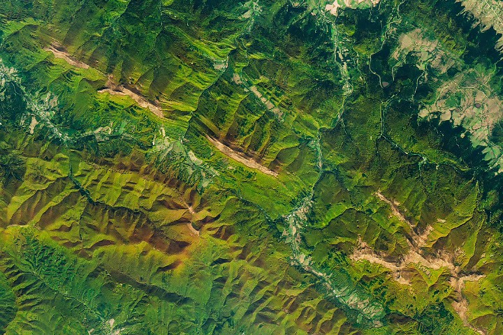
NASA Earth Observatory опубликовало 19 октября осенний вид Бещад, гор на юго-востоке Польши. На снимке чередуются зелёные и золотистые лесные склоны, а на гребнях выделяются светло-коричневые участки горных лугов. Изображение получено прибором OLI спутника Landsat 9 8 октября. Дата наблюдения отличается от даты сегодняшней публикации.
Иллюстрация подготовлена NASA Earth Observatory на основе данных Геологической службы США; это указание происхождения изображения помогает связать публикацию с конкретным источником наблюдений. В пояснении NASA связывает окраску лесов с европейским буком и другими листопадными деревьями. Когда дни становятся короче и температура снижается, производство хлорофилла сокращается, зелёный цвет ослабевает и заметнее становятся другие пигменты. Это объяснение сезонного процесса, а не сообщение о том, что необычный цвет сам по себе указывает на повреждение леса.
Выше лесных склонов находятся полонины — открытые горные луга и кустарниковые участки. Именно они образуют светлые полосы вдоль части гребней. NASA отмечает, что здесь лес уступает им место примерно на высотах от тысячи до 1260 метров. Разница оттенков поэтому отражает не только состояние листвы, но и различие растительности и положения в рельефе.
Такой снимок удобно читать как пространственную задачу. Сначала нужно понять, где проходят гребни и долины, затем отделить лес от открытых участков и только после этого сравнивать цвета. Если сразу назвать все коричневые места «высохшим лесом», разные элементы ландшафта окажутся ошибочно объединены. Подпись и описание прибора здесь помогают не меньше, чем само изображение.
Есть и временная граница. Один октябрьский кадр показывает состояние территории в конкретный день. Чтобы уверенно обсуждать изменение сроков осени за многие годы, понадобился бы сопоставимый ряд наблюдений. Из сегодняшней публикации такого вывода не следует. Это не уменьшает её ценности: хорошо объяснённое наблюдение полезно и без заявления о рекорде.
История ландшафта тоже шире текущей окраски. NASA напоминает о распространении буковых лесов после отступления ледников и о включении частей парка в сеть охраняемых древних буковых лесов UNESCO. Эти сведения дают контекст видимым склонам, но не превращают спутниковую фотографию в самостоятельную оценку всех природоохранных показателей территории.
Почему это важно
Изображение дня показывает, как сезонный процесс взаимодействует с высотной структурой растительности. Для читателя главное — связать видимую картину с датой, типом поверхности и масштабом вывода. Тогда красивый осенний снимок становится понятным наблюдением, а не поводом приписать ему неподтверждённую историю.
NASA Earth Observatory published an autumn view of the Bieszczady Mountains on October 19. Forested slopes in southeastern Poland alternate between green and gold, while tan mountain meadows mark parts of the ridgelines. Landsat 9's OLI instrument captured the image on October 8. The observation date is distinct from today's publication date.
The illustration was prepared by NASA Earth Observatory using US Geological Survey data, explicitly linking the published image with its observational source. NASA's explanation connects the forest colours with European beech and other deciduous trees. Shorter days and falling temperatures reduce chlorophyll production, weakening green and making other pigments more visible. This describes a seasonal process, rather than establishing that an unusual-looking colour by itself signals forest damage.
Above the wooded slopes are polonina: open mountain meadows and shrubby areas. These form lighter strips along some crests. NASA notes that forests give way to them at approximately 1,000 to 1,260 metres in this area. Differences in colour therefore reflect vegetation types and position within the terrain as well as the condition of leaves.
The image is useful to read as a spatial problem. Identify ridges and valleys first, distinguish forest from open ground, and only then compare colours. Immediately describing every brown patch as dried-out forest would wrongly combine different landscape elements. The caption and instrument information help interpret the image as much as its visual appearance does.
A temporal boundary matters too. One October scene records conditions on a particular day. Drawing conclusions about changes in autumn timing over many years would require a comparable sequence of observations. Today's publication does not establish that result. Its value does not depend on claiming a record: a clearly explained observation is useful on its own terms.
The landscape's history also extends beyond its present colour. NASA discusses the spread of beech forests after glaciers retreated and notes that parts of the park belong to UNESCO's network of ancient beech forests. That context enriches the visible slopes without turning a satellite photograph into an independent assessment of every conservation indicator.
This is a useful distinction for images circulated away from their original captions. Once a date and explanation are lost, a landscape can acquire a much stronger claim than the source supports. Keeping those details attached preserves the difference between seeing a pattern and establishing why it occurred.
Why it matters
The image of the day shows a seasonal process interacting with vegetation's elevation pattern. Its meaning comes from connecting visible features with date, surface type and the scope of the conclusion. Read that way, an attractive autumn picture becomes an intelligible observation rather than evidence for an unsupported story.
Источник:Source: https://science.nasa.gov/earth/earth-observatory/autumn-paints-polands-bieszczady-mountains/